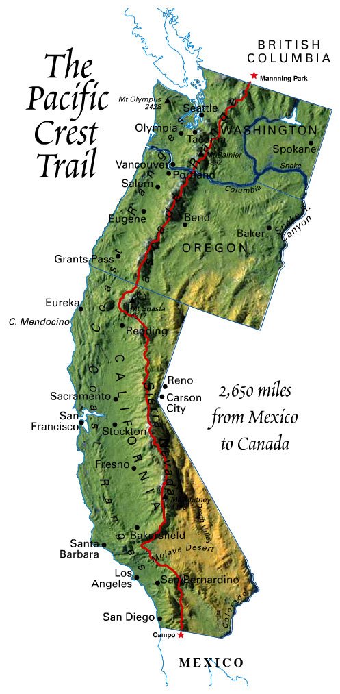
The Pacific Crest Trail (PCT) is long-distance hiking and equestrian trail which lies 100-150 miles east of the Pacific Coast. The trail's southern most terminus is on the US/Mexico border and the northern terminus is on the US/Canada Border on the edge of Manning Park in British Columbia, Canada. The trail is 2,668 miles long, traverses through California, Oregon and Washington, ranges in elevation from sea level to 13,153 feet, passes through 25 national forests and 7 national parks. The trail runs mostly through national forest and protected wilderness, avoids civilization and passes through the Mojave Desert in Southern California, the Laguna, San Jacinto, San Bernardino, San Gabriel, Liebre, Tehachapi, Sierra Nevada and Klamath mountain ranges in California and the Cascade Range in California, Oregon and Washington.
Thru-hiking refers to hikers that complete long distance trails from end-to-end in a single trip. The Pacific Crest Trail is one of 3 long distance trails in the U.S. the other 2 are the Appalachian Trail and the Continental Divide Trail. Thru-hiking the Pacific Crest Trail usually takes between 4 to 6 months to complete. The popularity of thru-hikers has grown tremendously over the past years, it is estimated that there are somewhere around 700 +/- thru-hikers attempting the PCT in 2014. Usually the completion of the PCT is around 50% each year, with most dropping by Kennedy Meadows around mile 700. The trail is unofficially divided into 3 parts: miles 0-702 Southern California (The Desert), miles 702-1698 Northern California (The Sierras), miles 1698-2668 Oregon and Washington (The Cascades). Each section provides different elements and challenges. The desert hot and dry with limited water. The Sierras with higher elevations and more difficult terrain, The Cascades with rain and possible early snow. Most thru hikers start at the Southern part of the trail and hike North, but there are also those that start at the Northern part of the trail and hike south. The challenge of the PCT and completing it has a lot to do with weather and timing. Leave too early in the season and you will be in Kennedy Meadows too early with snow in the Sierras and some of the trail impassable. Leave to late and you are at risk for snow storms and impassable trails in Washington. Northbound hikers usually start in the months of March, April and May. With the majority leaving in April. Most through hikers will arrive in Manning Park, British Columbia the last part of September or 1st week of October.
There are two ways hikers resupply along the trail, buy as you go or send resupply boxes. There are 40+ opportunities to resupply on trail which include Post Offices, small towns, road access to bigger towns within 20 miles of the trail, and stores along the way, usually ranging anywhere from 3 to 12 days between resupply points.
With the growing number of thru-hikers, even as a solo-hiker you meet many hikers along the way and are not alone in your journey. There is a community that is developed each year amongst thru-hikers and those that support them (trail angels) along the way.
Some common PCT terminology:
NO-BO, northbound hikers starting at the southern most part of the trail, the US/Mexico Border, *majority of thru-hikers
SO-BO, southbound hikers
Zero Day, rest days with 0 miles hiked on the PCT
Near Zero Days, small milage days with majority of day being a rest day (most often happens at resupply points)
Trail Angels, people that help thru-hikers along the way, some live near the trail and host hikers and accept resupply boxes, offer meals, a place to sleep, do laundry and rest, others are out leaving water caches (jugs of water to refill your water supply) out on the trail, or offering hikers rides to nearby towns, filling drop boxes with food
Trail Name, thru-hikers will be given a trail name along the way...at this point forward you are known on the trail by your trail name, real names are rarely used and once your trail name is given few will know you by your actual birth name
HYOH, Hike Your Own Hike -with all the changes in backpacking and trends in Ultralight backpacking, ways to resupply along the way, and opinionated personalities out there, you are likely to get criticized by your style of hiking , the most important thing to remember is that this is your hike not theirs, there's no right or wrong way to do it, although people will think that and tell you so. That's not to say you will adapt as you go. Your hike is going to look much different in the first couple hundred miles to the last hundred miles. You learn as you go.
Resupply Boxes, Boxes that you have prepared for yourself ahead of time, before you leave for your hike with supplies, most often filled with food and other small supplies you need to restock along the way, mailed to the post office of the resupply point. Post offices along the trail are accustomed to receiving these hiker boxes. You either mail these out before you leave for your hike or have a point person at home that will be mailing these boxes for you as you go
Bounce Box, similar to a resupply box, but this is a box with supplies that you may only need at resupply points, that you keep mailing ahead of yourself to each resupply point you stop,
Drop Box/Hiker box, boxes along the trail where fellow thru-hikers may leave food and supplies they no longer need or don't want and/or also surprises left by trail angels, up for grabs by fellow thru-hikers (also another term hikers call there resupply boxes)
So with all this said this is what my PCT thru-hike looks like to me:
My plan is to hit the trail, on May 21st, this is about one month later then the main group of thru-hikers usually leave, but my milage goals are a little higher and ambitious so I have hopes of slowly catching others as I go. I have an overall goal/daily average of 22 miles/day. Starting off close to 20miles/day. Dropping milage through Sierras to adjust to climbing and elevation. And ending with possibly 25+ miles/day. Keep in mind these are averages only. There will be days that aren't close to any of these numbers, one cannot prepare for actual elements of the trail, so you adjust as you go. I have around 17 resupply points I have selected along the way. Most of my food I am planning on preparing ahead of time, but also I will buy along the way, I am really nontechnical with the resupply strategy just dividing miles between resupply points by my 22mile/day average to get days between resupply points and allowing at least 3000cal/day in each resupply box. That calorie per day is low but that is my number I am sending to myself ahead of time, this doesn't include the food I will be buying along the way to add to my daily caloric intake (i.e. jars of peanut butter, tortillas, whatever I may be craving at my next resupply point) I anticipate my daily caloric intake ranging around 4000cal/day???
My goal is to take the least amount of zero day possible, allowing zero days for illness and injury. But using near zero days at resupply points for rest. But again I'll just go with the flow.
I need to finish the trail by no later then October 5th to get myself to my brother's wedding in Wisconsin on October 11th. That is a total of 137days from one end to the other. That's 122 days of 22mile/day plus 15 extra days.
Stay tune for future posts of gear reviews, pre PCT projects and preperations.
No comments:
Post a Comment
Note: Only a member of this blog may post a comment.